Darling Harbour: through the lens
For many years Darling Harbour was the working port for Sydney. The area was home to a myriad of finger wharves, shipyards, factories and warehouses and the thousands of people who worked there lived in nearby The Rocks and Millers Point, often in crowded and insanitary slums. Eventually the warehouses and railways yards gave way to a modern retail and entertainment precinct, a Darling Harbour that would be unrecognisable to the Sydneysiders of 100 years ago.
The whole of Darling Harbour was a web, connecting land and sea, hinterland and coast, Sydney and the outside world
(Johnson, p.57)
Early Darling Harbour
Darling Harbour was known to the original inhabitants of the Sydney area, the Cadigal people, as Tumbalong (the southern part) and Koodgi (the northern point).[1] The First Fleeters called the area Long Cove (a reference to the length of the bay) and by 1804, it was known as Cockle Bay, after the large amounts of shell middens in the area. At this time, there were only 18 houses in Cockle Bay while the rest of Sydney had more than 500 homes.[2] In 1811 Governor Macquarie commissioned Market Wharf, built on the site of the present-day aquarium. The wharf became a bustling centre for produce to be unloaded and taken straight to the town markets that operated on the site of the present-day Queen Victoria Building. In 1826 Governor Darling renamed the area after himself.
The power of steam engines arrived in the Colony in 1815 and a number of flour mills used this new technology.[3] This brought an increased demand for engineering workshops and Darling Harbour became home to shipbuilding yards, textile industries, galvanising works, gas works, power stations, wool stores and frozen food companies over the decades.
Railyards
When the first railway opened in Sydney in 1855 it included a single line to Darling Harbour. The railway yard was situated at the Ultimo/Pyrmont end of the Harbour. By 1874 the railway goods yard was extended on reclaimed land and by 1891 all outwards goods traffic was being dispatched from Darling Harbour. By the 1960s the Goods Yard encompassed 56 acres (22 hectares), including 50km of track transporting 13,500 trains a year.[4] The last goods train departed Darling Harbour in 1984.
Pyrmont Bridge
In 1857 the first Pyrmont Bridge was built as a private enterprise. The bridge connected the burgeoning western suburbs with the City. It was a toll bridge and charged 2 pence for pedestrians and 9 pence for carriages[5] It was purchased by the Government in 1884 for £49,600.[6] Work on a replacement bridge began in September 1899 and the new bridge opened on 28 June 1902. It was a steel bridge with a electrically operated swing span section that was powered by the Ultimo Powerhouse. The swingspan allowed access for tall vessels to the inner harbour area. On 7 June 1981 the bridge was closed to all traffic and reopened in 1988 as a pedestrian bridge.
The Argyle Cut
The Argyle Cut was started in the 1830s and finished in 1859.[7] It was created to provide a direct transport link between Sydney Cove and Darling Harbour and it remained an important transport link until Hickson Road was finished in 1923.
Plague arrives in Sydney
Arthur Paine, a carter who worked in the wharf area, was the first person diagnosed with the plague on 19 January 1900.[8] By March, with the number of confirmed plague cases increasing, the NSW Government and the Sydney Council began a quarantine and cleansing operation in The Rocks, Millers Point and down to Darling Harbour (as well as certain areas in Woolloomooloo, Paddington, Redfern and Manly). From 24 March to 17 July 1900, local residents were employed to cleanse, disinfect and fumigate the quarantined zone while rat catchers caught over 44,000 rats.
The bubonic plague was epidemic from 19 January to 9 August 1900. While 303 people were stricken with the plague and 103 people died, only 3 of the dead lived in The Rocks.
More about the plague
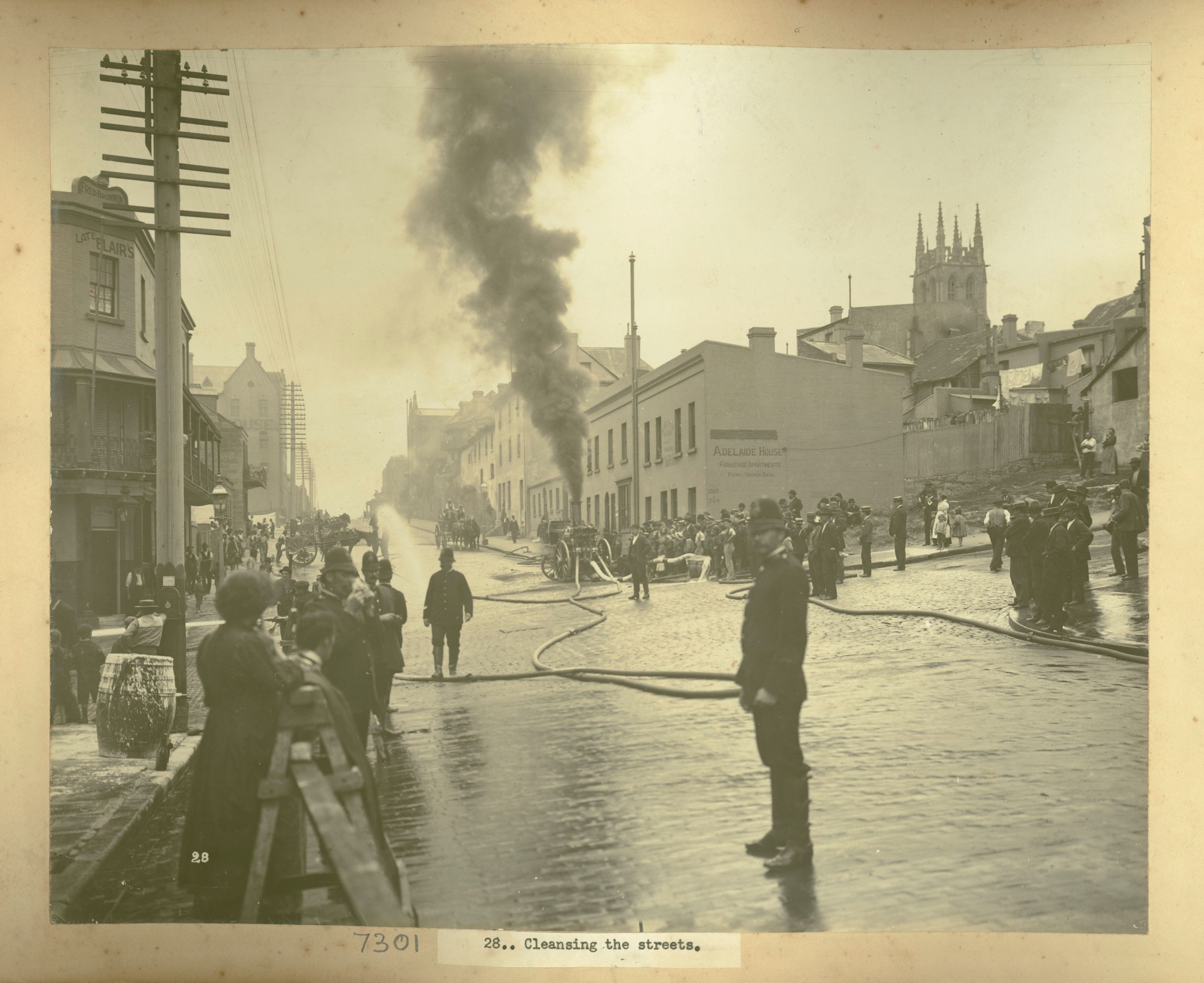
Purging Pestilence – Plague!
The Bubonic Plague hit Sydney in January 1900. Spreading from the waterfront, the rats carried the plague throughout the city. Within eight months 303 cases were reported and 103 people were dead
Resumptions
In response to the plague the NSW Government set in motion plans to resume almost the entire headland from Circular Quay to Darling Harbour. The Darling Harbour Resumption Advisory Board was established to oversee the resumptions, which included houses, wharves, factories, mills, hotels and warehouses. Initially 900 houses were bought in The Rocks and then in 1923 another 300 homes were resumed for the building of the Sydney Harbour Bridge.[9] Private wharves became government property and local residents became public tenants. One of the early tasks undertaken by the Board (taken over by the Sydney Harbour Trust, which was established in October 1900), was establishing rat proof walls and wharves, like Wharf 3 in Darling Harbour. The Sydney Harbour Trust was established for the purpose of controlling, administering and developing the port.[10]
Decline and revitalisation
The decline of Darling Harbour was slow. The shipbuilding industry slowed after World War II and the increased use of large container ships around the world meant that Darling Harbour, with its finger wharves was not ideally situated to cope with these changes. In the 1960s the establishment of a container terminal at Port Botany marked the death knell for Darling Harbour as a major commercial port. In 1984 the Darling Harbour Authority was established to plan the redevelopment of the area. Modern day Darling Harbour was “created as a gift to the people of NSW in celebration of Australia’s bicentenary in 1988.” [11] Darling Harbour was reborn as a tourist destination, playing host to a variety of entertainment facilities, shops, bars and restaurants. One wonders how many more transformations there will be for the Harbour area in the future?
Timeline
Pre 1788 Darling Harbour is known as Tumbalong and Koodgi by local Gadigal Aboriginal people
1788 First Fleeters call Darling Harbour Long Cove
1804 Darling Harbour known as Cockle Bay after the seashells found there
1810 John Leighton builds a windmill at Millers Point
1811 First wharf, Market Wharf, is built at the foot of Market Street
1826 Governor Darling renames the area and it grows to become a busy seaport
1855 First railway in NSW opens, including a branch line to Darling Harbour
1857 First Pyrmont Bridge is built as a toll bridge
1874 Iron Wharf at the southern end of Darling Harbour is completed
1900 Outbreak of bubonic plague
1900 Sydney Harbour Trust formed to oversee redevelopment and resumptions in Darling Harbour
1902 Pyrmont Bridge replaces with swing span bridge
1912-25 Sydney Harbour Trust plan to redevelop Walsh Bay, Darling Harbour and Pyrmont
1923 Hickson Rd completed as major thoroughfare from Circular Quay to Darling Harbour
1926 Debris from construction of the underground railway in Sydney used to reclaim head of Darling Harbour
1960s Decline & Botany Bay port
1984 Last goods train leaves Darling Harbour
1984 Darling Harbour Authority formed to redevelop former railyards and wharves
1988 Redevelopment project opens to public as entertainment and shopping precinct
Footnotes
[1] Johnson, p.10
[2] Ibid., p.16
[3] Ibid., p.22
[4] Ibid., p.64
[5] darlingharbour.com (cited April 2018)
[6] darlingharbour.com (cited April 2018)
[7] Johnson, p.58
[8] http://www.therocks.com/
[9] Ibid.
[10] Sydney Ports_ Wharf 3
[11] shfa.nsw.gov.au (cited April 2018)
References
Darling Harbour – Chronological History, accessed 24 June 2013
Darling Harbour – Pyrmont Bridge, accessed 24 June 2013
Wayne Johnson and Roger Parris, A History of Sydney’s Darling Harbour, Sydney Harbour Foreshore Authority, 2008
Sydney Harbour Foreshore Authority, Darling Harbour, accessed 24 June 2013
Sydney Harbour Foreshore Authority, Darling Harbour Rail Corridor, accessed 24 June 2013
Sydney Harbour Foreshore Authority, The Rocks – Twentieth Century Transformations, accessed 3 July 2013
Sydney Ports Corporation Heritage Inventory, Study Number 4560019 Sandstone Seawall, Wharf 3, Darling Harbour, accessed 3 July 2013
Research by
Suzanne Upton, Archivist Public Access
Published on
More stories
Browse all
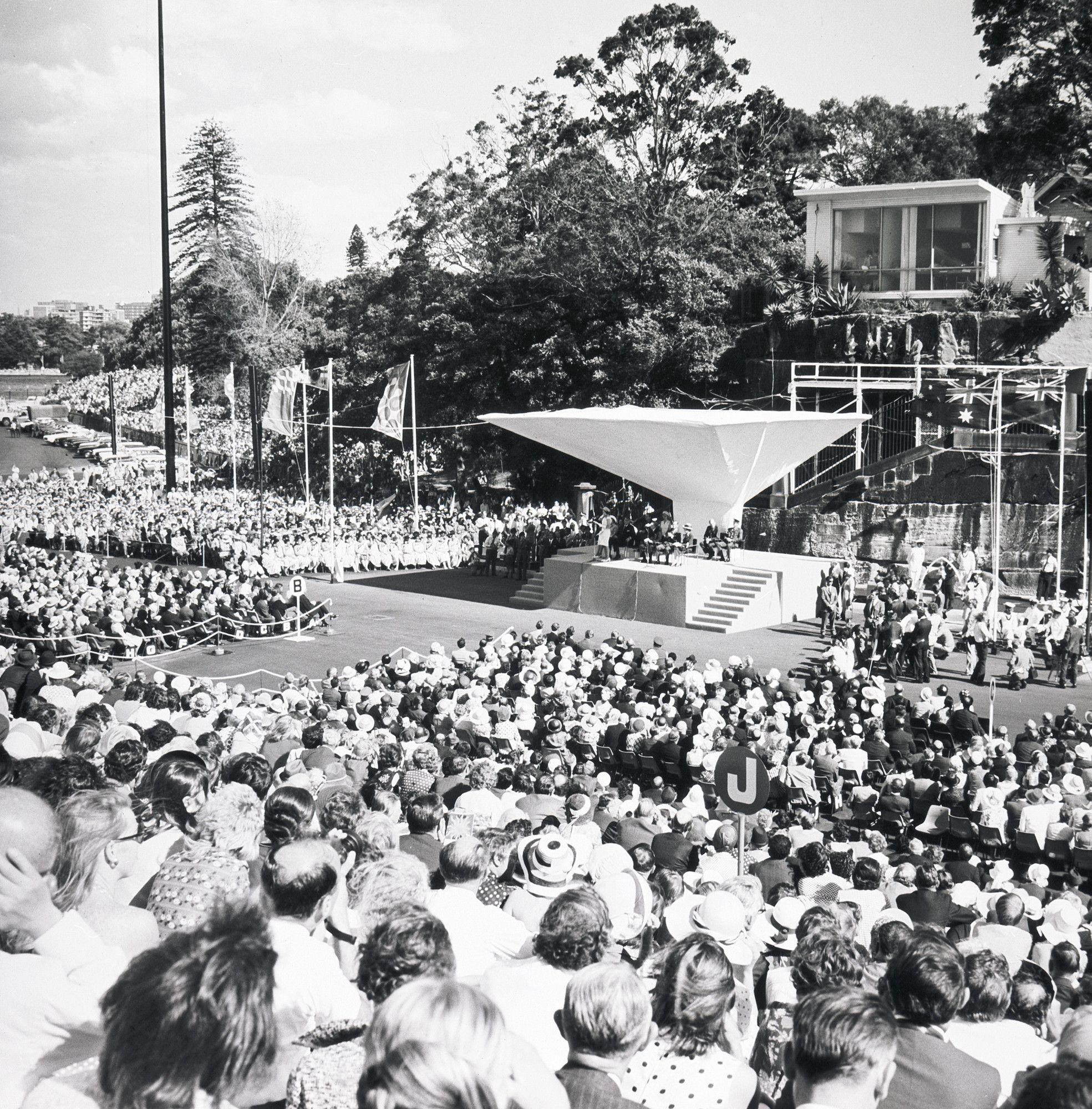
Celebrating federation
The Commonwealth of Australia was proclaimed on 1 January 1901. The Federation Pavilion in Sydney’s Centennial Park was the focus of the inauguration ceremonies and a five mile procession through the decorated streets of Sydney was greeted by large crowds
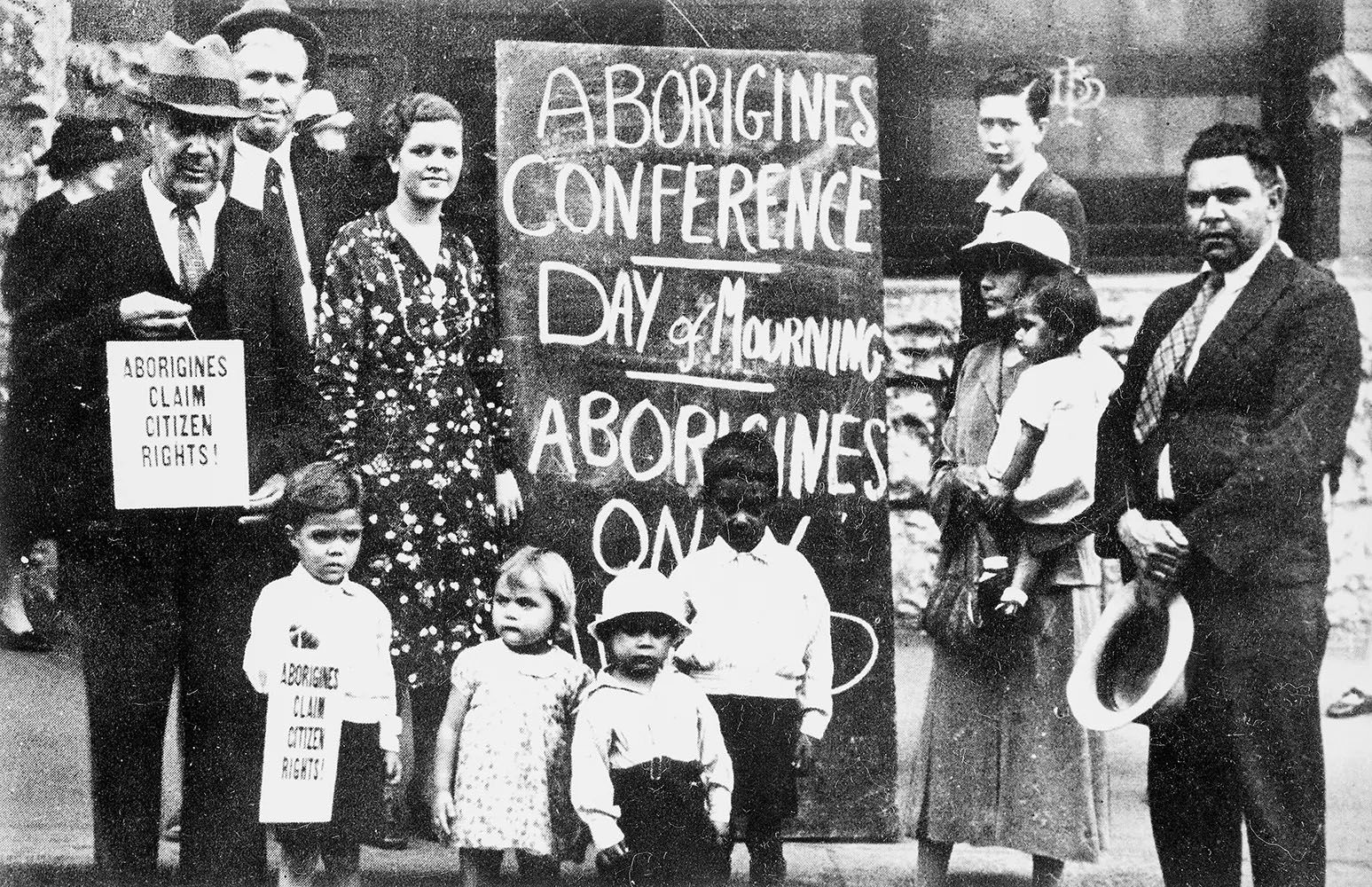
First Nations
Day of Mourning
January 26 has long been a day of debate and civic action. Those who celebrate may be surprised of the date’s significance in NSW as a protest to the celebrations of the anniversary of the arrival of the First Fleet on what was then “Anniversary Day” in NSW
The Sydney Opera House Books
Significant publications and reports on the Sydney Opera House project, including the rules for the design competition, plans, drawings and photographs at various stages of the construction