County & parish maps guide
An overview of county, parish and town/village maps created by the Department of Lands and its predecessors and a background to the digitisation of the parish maps now available on the NSW Land Registry Services Historical Lands Records Viewer.
Background to the maps
In 1825 Royal Instructions were issued to Governor Brisbane ordering a general survey of the colony of New South Wales and its division into counties and parishes. County and parish maps have been used for over 150 years to record Crown land dealings.
Two sets of county, parish and town/village maps were created and maintained by the Department of Lands and its predecessors. One set of maps, for a particular area, was kept at the Local or District offices and a duplicate set for the whole State was kept in the Head Office of the Department.
Both sets were annotated to show changes in the status of the land. The District Office maps, however, often contain information not recorded on the Head Office versions. Once a map could no longer be easily annotated it was 'cancelled' and a new edition printed.
Types of Maps
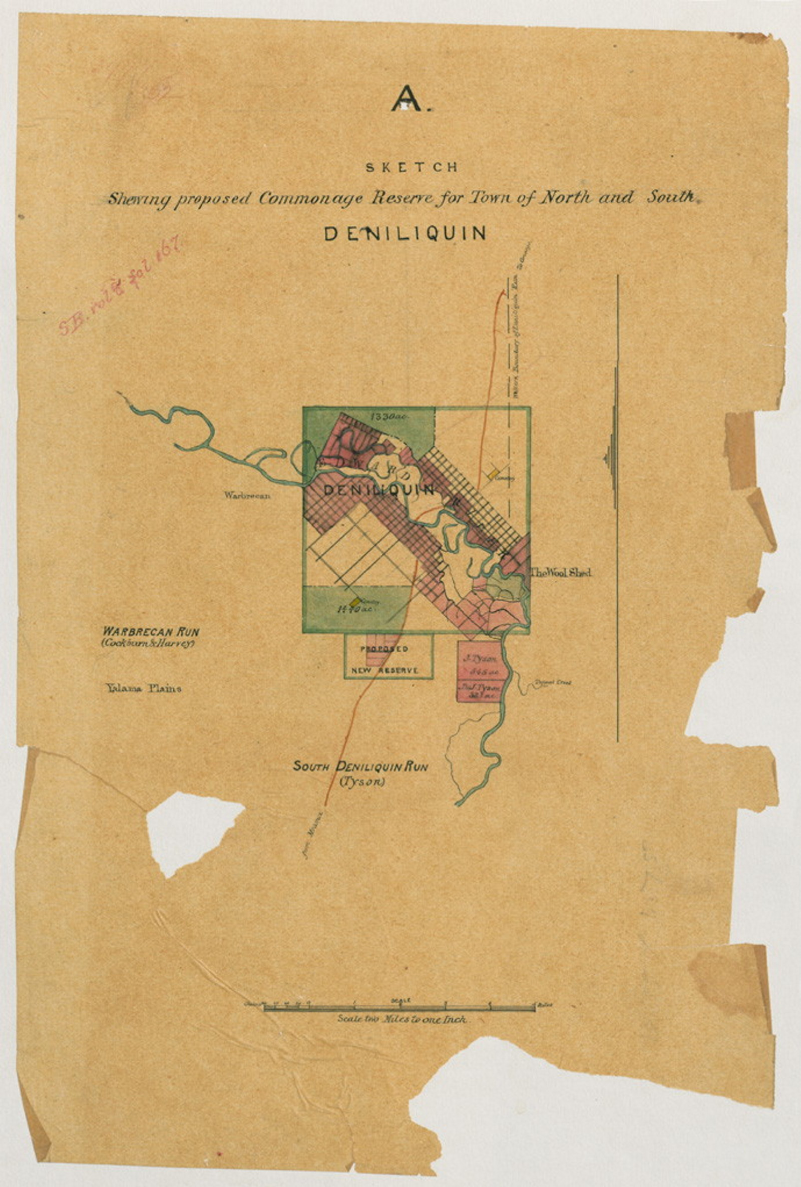
County maps
There are 141 counties in New South Wales. The maps show the division of counties into parishes, major physical features and large portions with their numbers. County maps usually have a scale of 4 miles to an inch. County maps are the main historical reference map for the Western Division, except for proclaimed towns and villages that have their own maps.
Parish maps
The 141 counties are divided into 7,515 parishes. Parish maps are produced for the Eastern and Central divisions of New South Wales. They have not been compiled for the Western division, or for 'private' towns subdivided out of privately owned land. Parish maps usually have a scale of 4 inches to a mile.
Features on a parish map
Portions with area and original grantee or tenure, references to Crown Plans and the survey plan reference are shown. Other features can include place names, notes, boundaries, roads, reserves, freehold, incomplete purchases and reference notes. Parish maps are a very useful source when researching a locality or as a starting point for researching a portion of land.
Cancelled parish maps
Parish maps are annotated to show changes in the status of land. A new edition is issued when it becomes difficult to record new information on a map. The older edition is then marked 'cancelled'.
To locate a parish name
Researchers should consult Gleeson: An alphabetical list of names, which is available in the reading room and on the Geographical Names Board website. Parish names are often duplicated across New South Wales. It is therefore necessary to identify the parish by including the name of the county.
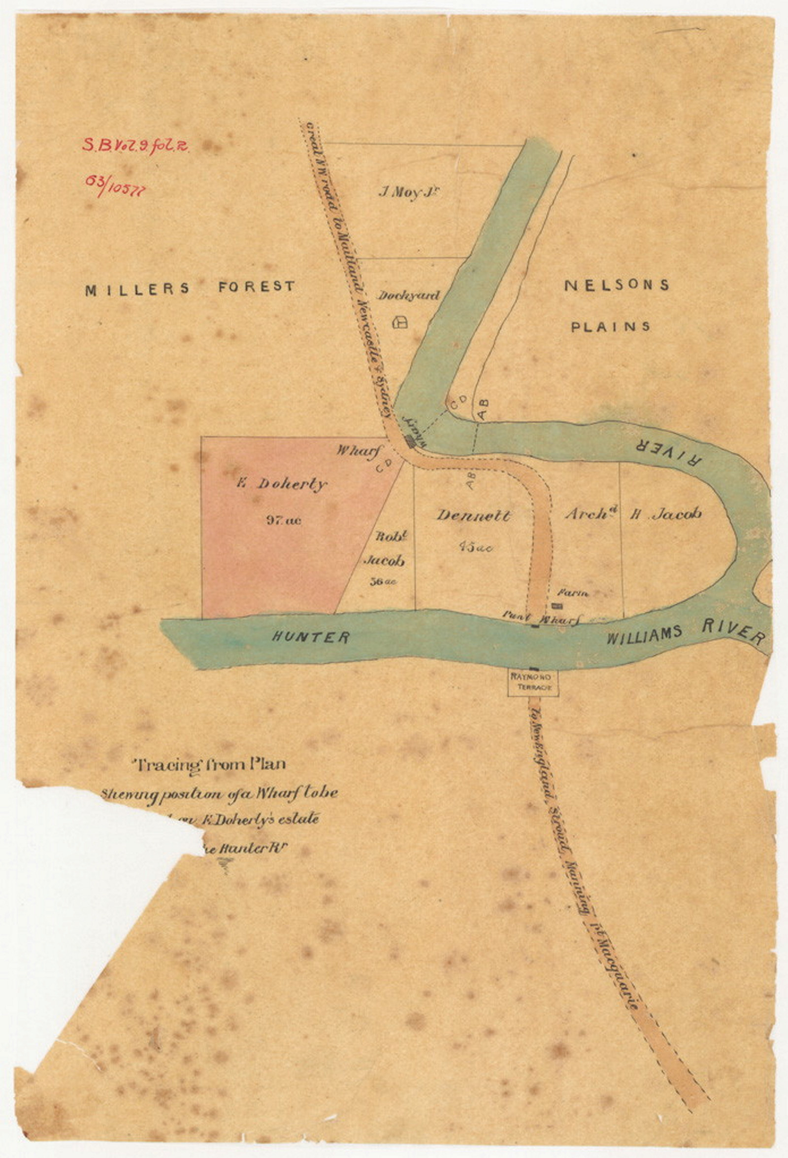
Town and village maps
Town maps are similar in detail to parish maps. Town maps refer to allotments rather than portions, and are at a larger scale than parish maps.
Crown plans
‘Crown plans’ or ‘Portion plans’ are compiled to provide historical information about a portion of land.
Crown Plans are held in the NSW State archives collection as NRS 13859. The earliest Crown plans are listed in the online Index to Surveyor General’s Crown Plans.
Later Crown Plans are available from NSW Land Registry Services (LRS). As they are digitised copies of the plans are progressively available for viewing on the LRS Historical Lands Records Viewer (HLRV) public terminals in our reading room. Copies of the Crown Plans are not accessible on HLRV terminals at the NSW State Library or at LRS NSW.
Once an image becomes available on the HLRV, high quality digital copies may be purchased from NSW LRS. If you are interested in a digital copy of an early Crown Plan listed in the online index that has not yet been digitised please contact State Archives Reading Room staff.
To locate a Crown Plan on the HLRV you need to use the catalogue number, or the State Archives Map number, if it is an early Crown Plan listed in the online index. It will help to know the names of the county and parish, the portion number and the catalogue number. These details are shown on a parish map.
Digitisation of the parish maps - the Parish Map Preservation Project
Over 35,000 maps, recording land administration in New South Wales since 1792 have been copied and made available for public access.
Native Title investigations highlighted the need to preserve and provide convenient access to early edition parish maps. To assist investigations The Parish Map Preservation Project began by copying pastoral holdings maps. After the 'Wik' High Court decision - that pastoral holdings may no longer extinguish Native Title - the Project concentrated on county, parish, town and village maps.
Aims of the Project
By creating a digital copy of every edition of every county and parish map of New South Wales the project aimed to:
- create a complete collection of maps
- increase access to the maps throughout NSW
- help preserve the often fragile originals, and
- allow colour copies to be made.
Progress of the Project
Copying commenced in mid-1997. The first maps to be copied were pastoral holdings maps. When the Project altered its focus to county, parish and town/village maps, the District Office maps were the first priority for copying.
As the District Office maps are not complete, it was necessary to supplement the collection with Head Office maps. Where neither a District Office nor Head Office edition could be located, a map created by another Head Office branch (for example Roads branch) or the Department of Mineral Resources was used. There have been instances where editions could not be located.
All available editions of historical parish, town, municipal, county and pastoral maps have now been digitised. Current versions of the maps were then copied.
Historical Lands Records Viewer
Since the digitisation of the parish, county and town maps other land titling records have been digitised and made available on the NSW LRS Historical Lands Records Viewer. These records include:
- Charting maps (including County, Parish and Town)
- Plan lodgment books 1863-1995
- Historical maps (cancelled editions of Crown land parish maps)
- Real Property dealings
- Crown plans
- Deposited plans
- Grant Index and Register 1792-1862
- Vendors Index 1825-1986
- Purchasers Index 1896-1985
- General Register of Deeds (Old System deeds) 1825-1992
- Manual Torrens titles
- Old System records
- Miscellaneous historical plans
- Surveyor's Field Book Index
- Torrens Purchasers Index
- Old Form Torrens Register 1863-1961
The LRS website provides information about these records, how to search them and how to order copies. When the records are digitised, the originals are transferred into the NSW State archives collection.
Copying process
Originally digital cameras were used to photograph the maps. The images were downloaded and opened into 'Photoshop'. A master image is stored at NSW LRS. The images are available for viewing on the LRS Historical Lands Records Viewer (HLRV) at 255 dpi. More information about the digitisation of land titling records is available on the NSW LRS website.
Preservation of original documents
Many of the surviving parish maps, including most Head Office maps, were already held in the NSW State Archives Collection. To ensure their preservation maps that had been held by the District Offices were transferred to NSW State Archives once they were copied. Records subsequently digitised were also transferred to the NSW State Archives Collection after digitisation.
How to access the maps and other digitised records on the HLRV
When a record has been copied
To protect and preserve original records once they have been copied, the original will not be made available in our reading room.
You can view the records:
On the NSW Land Registry Services Historical Lands Records Viewer
Aside from the Crown Plans, digitised records can be viewed on the NSW LRS Historical Lands Records Viewer. In addition terminals are available in our reading room, at the State Library of NSW and at LRS Queen Square.
Crown Plans
Digital copies of Crown Plans may only be viewed on the public HLRV terminals in our Reading Room. Copies of the Crown Plans are not accessible on HLRV terminals at the NSW State Library, at LRS Queen Square or via the HLRV website.
Parish maps on CD
Digital copies of surviving county, parish, and town and village maps of NSW were made as part of the original Parish Map Preservation Project. A set of the CDs with images of the maps is available for viewing in our reading room. These images are also available for viewing on the HLRV.
When a record held in the NSW State archives collection is not copied
Records that have not been copied, such as maps created and maintained by other branches of the Department of Lands (for example Roads Branch) or other public offices can be identified by using the card index to maps and plans in the reading room. If the record has not been copied, and it is not damaged or fragile, and is not considered to be closed to public access, we will provide access to the original.
Obtaining copies of the records
Digitised records available on the HLRV
- Information about obtaining copies is available on the NSW Land Registry Services website.
Aperture card copies in the reading room
Many early Crown Plans and some parish maps have been copied onto aperture card. These are 35mm black and white negatives. It is possible to obtain prints and digital copies of these in our reading room. Please note however that due to the condition of some originals (damage, faint writing) copies from 35mm black and white negatives are not always legible.
Uncopied original maps held by us
A3 size black and white photocopies of most uncopied maps can be ordered from NSW State Archives for a fee. Please discuss your order with reading room staff.
Alternatively you are welcome to photograph the map in the reading room.
If a map is copied, you may not copy from the original.
Further reading
NSW Land Registry Services: Fact Sheet - Historical Parish Maps. Available on the NSW Land Registry Services website.
NSW Land Registry Services: Searching the Registrar General's Maps and Plans. Available on the NSW Land Registry Services website.
Land guides
Browse allLand records available at NSW State Archives
A joint initiative between NSW State Archives and Lands and Property Information (LPI) to provide online access to a number of historical land title records was announced in November 2010. Using the popular search tool PIXEL (now HLRV) researchers can now search and view Old Form Torrens Title Registers, Charting Maps and Crown Plans online
Primary application packets guide
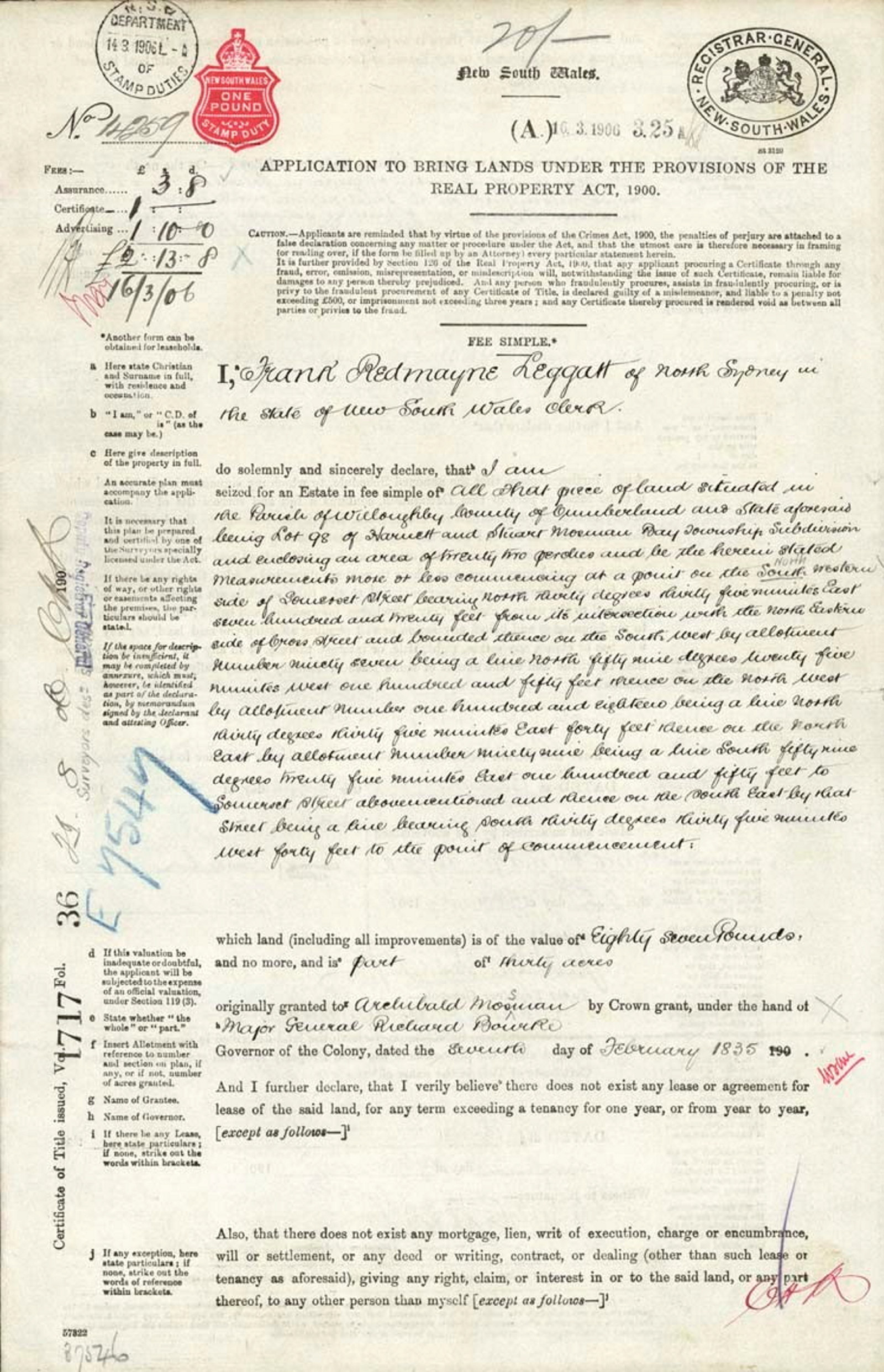
The Real Property Act, 1862 established a system whereby owners could convert land granted prior to 1863 to Real Property Act title. This is done by what is called a Primary Application
Commissioners of Crown Lands guide
A brief overview of the major sources and key related series we hold that relate to the Commissioners of Crown Lands
Conditional purchase of crown land guide
This Guide provides an historical background on the conditional purchase scheme in NSW from 1862 to 1951, also known as 'free selection before survey' along with a list of the major record series and step-by-step guidance on how to access them