Historic houses in 3D
A project to capture 3D scans of MHNSW properties will greatly assist conservation work and create exciting new interpretation opportunities far into the future.
A recent investment of capital stimulus funding by the NSW Government has enabled us to start building a complete digital record of all of our sites and properties. Using light detection and ranging (LiDAR) technology, which employs pulsed lasers to calculate an object’s size, the project will capture detailed measurements of every MHNSW site with expected accuracy to within a millimetre. This large-scale project will run through to June 2022 and involve museum, curatorial, heritage, collections, and digital and design team staff.
Modelling buildings and landscapes
The technology will be used to capture both exteriors and interiors at our properties, creating accurate digital records of the built fabric and including details such as cornices, timber panelling and ceiling roses. It will also scan the landscape around the buildings, showing Rouse Hill House’s location within the contours of the historic farm, for example, and the Justice & Police Museum nestled between high-rise buildings at Circular Quay. The measurements are captured with data points, forming what’s known as a point cloud. As well as size and shape, the process also maps the texture of surfaces, capturing colours, blemishes and details such as wood grain, painted highlights or stains in sandstone and creating a rich visual record.
This point-cloud data will then be used to create a number of assets. 3D drawings will give us the most accurate set of drawings of our sites the organisation has ever had. While they won’t capture every cavity, such as underfloor spaces or attic areas, they will include plant rooms and offices, forming a rich resource for heritage or building works.
Conserving our sites
The work will also provide a platform for us to create full building information models. These will allow us to document conservation work as it takes place at each site, showing materials used and where building services such as plumbing run, and link to additional information, such as manufacturer specifications or photographs of the work. Over time, by capturing key information in an easily accessible format for use by Building & Facilities or Heritage Team staff, these models will expedite the scoping of future work.
Because the point-cloud data creates an accurate record of a site at a particular point in time, it will provide a useful reference to assess any deterioration in a site’s condition. Should a ceiling show signs of drooping or a drop in the floor indicate subsidence, the point-cloud data can be used to precisely determine the amount of movement and therefore whether intervention is required.
In the worst-case scenario that one of our sites is damaged by fire or in a natural disaster, the point-cloud data will also provide an accurate model to inform reconstruction. Following the major fire at Notre Dame in Paris in 2019, 3D scans taken of the cathedral in 2010 are being used to inform the reconstruction.
Interpreting our sites
From the scans, we’ll soon be able to create web-based walk-throughs of all of our sites that can be easily accessed via a browser. As shown in the example above, these can be augmented with text, audio or video content, allowing us to provide rich virtual tours of our museums and give visitors access to areas that are normally off limits or difficult to access, such as taking them inside the mausoleum at Vaucluse House.
Potential future applications of this data for interpretation are endless, including the creation of models for use in cinema, such as period backdrops in films. Advanced gaming engines such as Unreal Engine can ingest this point-cloud data to create lifelike experiences that users can walk through using a 3D headset, or which artists and filmmakers can use as the basis for creative works. Further advances in virtual and augmented reality technologies will also give us opportunities to create innovative and surprising new experiences for visitors to our sites.
Modelling the collections
As well as scanning buildings, we’re scanning key items from our collections. 3D models of these items can be placed into the virtual scenes, allowing us to explore new ways of interpreting our houses without needing to move fragile collection items or interfere unnecessarily with the built fabric. We’ll also be able to create accurate facsimiles of collection objects through 3D printing, enabling visitors to handle replica objects and offering those who are visually impaired a tactile way to explore our collections. Below is a 3D model of the 1788 headstone of First Fleet sailor George Graves, one of the original NSW State Archives Collection items included in the History Reflected exhibition. The model enabled us to create a 3D printed facsimile of the headstone to replace the real item, which had been on display at The Rocks Discovery Museum.
More
Browse all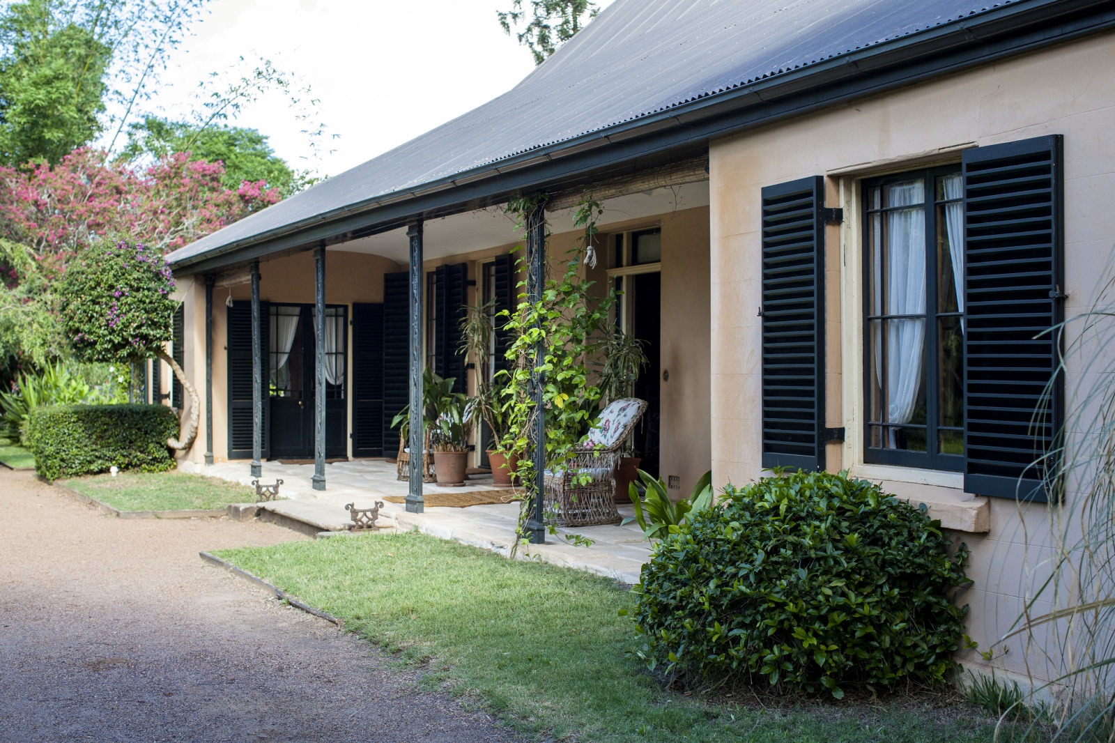
'A most excellent brick house' Elizabeth Farm
Curator Dr Scott Hill explores some of the enduring mysteries buried in the architecture of Australia’s oldest surviving homestead
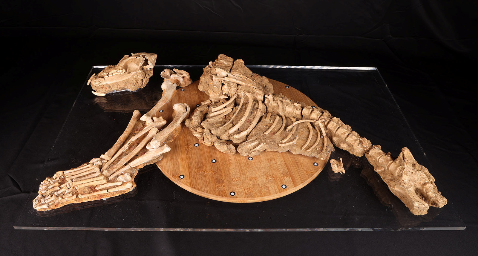
3D scanning the archaeological dog skeleton
A key component of Museum of Sydney’s interpretation is the archaeological remains of First Government House
Published on
Tim Girling-Butcher
Head of Digital & Design
Tim leads a creative team of design, digital and multimedia specialists supporting the delivery of MHNSW activities across our physical sites and online platforms. He has over 25 years of experience working in the cultural sector in Australia and New Zealand. He has led multiple creative projects across a variety of platforms including exhibitions, programs and digital interpretation. Tim’s journalistic training, fixation with technology and passion for audience engagement drive him to find new and exciting ways to tell stories in his current role as Head of Digital & Design for MHNSW. Tim is a published author and exhibition curator.